
September 17th through September 26th, 2024, the Fisters team monitored and made an intercept of Hurricane Helene along the Florida Gulf coast.
On September 17th, 2024 the National Hurricane Center (NHC) noted an area in the Western Caribbean Sea to watch for tropical cyclogenesis. A combination of extremely warm water in the Gulf of Mexico, very little wind shear, the Central American gyre, the prevailing La Niña conditions of the El Niño Southern Oscillation in the Pacific Ocean, and the Madden-Julian Oscillation contributing to cyclonic flow in the Western Caribbean told us that conditions were just right for hurricane formation. The Fisters team immediately began talks of deploying should it make landfall in the Southeast. On September 22nd, a broad low pressure system had formed in the Western Caribbean. On September 23rd, this system became Potential Tropical Cyclone Nine due to its threat to land. By September 24th, the Hurricane Hunters reconnaissance mission found winds to be 52 mph which prompted an upgrade to Tropical Storm Helene at 1500 UTC.
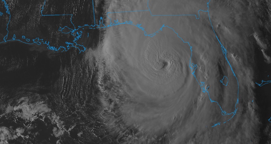
By 1500 UTC September 25th, the Hurricane Hunters reconnaissance mission found winds to be 80 mph which prompted another upgrade to Hurricane Helene. At this time, Hurricane Helene began a northward turn and was entering the Gulf of Mexico (GoM). An upper level trough was digging down into the GoM from the west and an upper level ridging pattern had set-up to its east. Helene continued to become better organized and larger as the day went on. The NHC noted in several of its discussion posts that Hurricane Helene was “at the 90th percentile of hurricane size at similar latitudes”. As it continued to track northward, intensification was halted for a short time as dry air entrainment was occurring.
Hurricane Helene was able to recover quickly and began to rapidly intensify on the morning of September 26th. Rapid intensification (RI) as defined by the NHC is an increase in wind speed by at least 35 mph in a 24 hour period. This process of RI was aided by minimal wind shear and extremely high sea surface temperatures exceeding 86℉ near the Gulf Loop current. By 1200 UTC September 26th, Hurricane Helene had reached Category 2 intensity. By 1825 UTC, Hurricane Helene had already become a Category 3 hurricane with winds exceeding 110 mph as found by the Hurricane Hunters reconnaissance mission. As Hurricane Helene neared landfall the night of September 26th, it reached its maximum intensity of Category 4 with winds of 140 mph and a central pressure of 938 mb. At 0310 UTC September 27th, Hurricane Helene made landfall near the town of Perry, Florida as a Category 4 Hurricane.
The Fisters team originally set up in Medart, Florida to collect meteorological data as landfall was occurring. However, we noticed that a turn more northeastward was occurring and attempted to reposition closer to landfall. However, we noticed the turn too late and were unable to make it safely to Perry. We did make it to Waukeena, Florida and we were able to sample from within the very intense eyewall. However, we wanted to sample the eye of the hurricane as well. So, we began to reposition for an intercept of the eye on Interstate 10 near the town of Greenville, Florida. As we made our way to I-10 via US27 and US19, the winds were extremely strong and trees nearly blocked our path to I-10. We made it to I-10 and were able to get in the eye for a short time before the eyewall ultimately made its way back onto us as we cleared trees from the roadway for several hours.

Leave a comment