
Days Leading up to Landfall
On August 28, 2024, a tropical wave had just emerged in the Atlantic off the West Coast of Africa. As the wave made its way across the Tropical Atlantic, little organization occurred. It reached the Leeward Islands on September 1st. Showers and thunderstorms continued to develop as the wave made its way through the Caribbean Sea, but with strong wind shear throughout the area, no more organization occurred. On September 6th, the wave had reached the Yucatán Peninsula and was moving into a more favorable area for organization. By September 7th, the wave emerged into the Bay of Campeche and it was noted that an area of broad low pressure had developed on September 8th. By daybreak on September 9th, a Hurricane Hunter Reconnaissance mission had discovered a closed circulation and the system was much better organized on satellite. By the 10am National Hurricane Center (NHC) update, the wave was upgraded to Tropical Storm (TS) Francine. At that time, TS Francine was 250 miles SE of Brownsville, TX moving to the NW at 5 mph. Later into the evening TS Francine continued to become better organized and eventually stalled out over extremely warm waters of the Gulf. By daybreak on September 10th, a trough over Texas and Mexico aided in steering TS Francine to the NE at 5-10 mph. The trough brought stronger shear and also allowed for mid-level dry air to begin entraining into the circulation, which caused TS Francine to halt any further organization or intensification. By the early evening hours that same day, a Hurricane Hunter Reconnaissance mission coupled with satellite and land-based radar showed sustained hurricane force winds at 75 mph in the storm. At 7pm CDT, the NHC upgraded the storm to Hurricane Francine.
Day of Landfall
By 1am CDT on September 11th, Hurricane Francine was 275 miles SW of Morgan City and had intensified even more with sustained winds of 90 mph confirmed by a Hurricane Hunter Reconnaissance mission, satellite, and land-based radar. Hurricane Francine continued to move NE at 10 mph towards the LA coast, with intensification leveling off by sunrise that morning. By late morning into early afternoon, a Hurricane Hunter Reconnaissance mission, land-based radar, and satellite imagery confirmed that Francine had strengthened even more with sustained winds of 100 mph and a minimum pressure of 972 millibars. This prompted the NHC to upgrade Hurricane Francine to a Category 2 hurricane at the 4pm CDT update. Hurricane Francine made landfall near the mouth of the Atchafalaya River, approximately 30 miles SSW of Morgan City, LA at 5pm CDT September 11th.
The Fisters Deployment
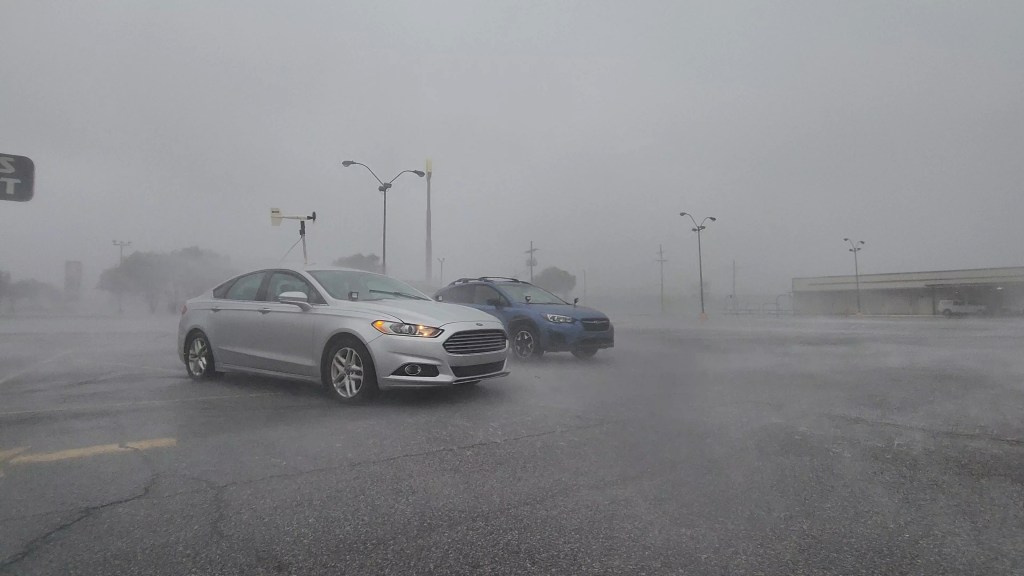
The Fisters team began talks of a deployment to Louisiana on the morning of September 10th. By that evening, we determined that we would be going and left Huntsville, AL headed towards Lockport, LA. We arrived there with several weather balloons as well as an anemometer in the hopes of collecting important information around 3am September 11th. We slept in a Rouse’s parking lot and discovered that they were actually open for half a day. We were able to have a nice lunch before departing to Morgan City, LA which looked to be exactly where landfall would occur. We arrived in Morgan City and parked in another Rouses Market right off of US Highway 90, which was our escape route should anything happen.
The winds really began to pick up in the mid-late afternoon hours, with sustained winds of at least 75 mph. As we got into the eyewall, we attempted to launch a weather balloon but the winds had become too strong and we were unable. At that time, we also realized that our anemometer was not reporting correct wind speed data. Since Morgan City has a levee around the entire town, we were not concerned with storm surge, but it became apparent that flash flooding would be an issue. As we neared the most intense part of the storm, water began to quickly rise in the parking lot, at an alarming rate. The Fisters team had already planned for this and quickly retreated onto the entrance ramp of US Highway 90, where we were at least 15 feet above the ground. At that time, we experienced the strongest sustained winds and gusts the Francine had to offer. Sustained winds were near 100 mph and gusts in the 120-130 mph range. The eye of Hurricane Francine appeared that it would pass south of us so in an attempt to get measurements from inside the eye, we attempted to travel south on Business Route 90 towards Siracusaville. We made it to Amelia and crossed the bridge over the Avoca Island Cutoff before we were forced to turn back due to trees. Steven had a tree-top fall on his windshield, which luckily did no damage, and we turned around and headed back to US Highway 90.
Once back in Morgan City, we determined that we should attempt to get out of the hurricane so that we could get a hot meal and change into dry clothes once we got to a hotel. We began driving on US Highway 90 toward Lafayette at a very slow pace. We still had gusts nearing 80-90 mph so we had to be careful with the trees as well as any water that may have entered the roadway. Luckily, we experienced no issues and made it safely to Lafayette, got food, and slept in a hotel room instead of our cars. We did not get any great data as no balloons were launched and the anemometer was found to be faulty.

Leave a comment